
A panoramic scene connecting a panoramic movie of Masonic Street with its famous Women's History Mural to a movie on Main Street
Monday, June 30, 2008
Northampton, Massachusetts Panoramic Scene 1
Sunday, June 29, 2008
Eldridge Street Synagogue Panoramic Scene
A 3 node panoramic scene made from 3 panoramic movies taken on June 15, 2008 during Eldridge Street Synagogue's annual egg cream and egg roll festival. The first movie (in the synagogue) links to the second and third that are outside on Eldridge Street. Panorama 2 is adjacent to the synagogue, while panorama 3 is up the block north at the intersection of Eldridge and Canal. The site being developed once housed Beny' s Watches, a long time LES establishment.
"Klezmer music, Chinese opera and acrobatics, language lessons, scribal art, folk art demos, crafts, tours and, of course, kosher egg rolls and egg creams! Experience a unique slice of Lower Manhattan, where Chinatown meets the old Jewish Lower East Side."
Camp Kingsmont 3 Node Panoramic Scene
A 3 node panoramic scene made from 3 adjacent panoramic movies taken on June 22, 2008 on the campus of Hampshire College (893 West Street Amherst, MA 01002). The first is the northernmost in a small parking area, the third is just SW of that and the second is SE. The 2nd panoramic movie is not really visible from the first. You have to imagine the hot spot going through a building and vice versa from the 2nd back to the first..
Friday, June 27, 2008
Franklin Avenue And Calyer Street Panoramic Movie
A panoramic movie made at the intersection of Franklin Avenue and Calyer Street
Greenpoint Pier Panoramic Movie
A panoramic movie made from the pier at the end of India Street in Greenpoint.
Oliver Street Panoramic Movie
A panoramic movie made on Oliver Street, between Henry and Madison Streets. Visible is the western side of PS 1 as well as the house that Al Smith lived in (there's a white car parked in front and you may be able to see a plaque on the wall). This was also the block that formerly housed Jimmy's Candy Store that sold comics in the 1950's and 60's (look for a green awning)
Pearl Street Panoramic Movie
A Panoramic Movie made at the intersection of Pearl and Dover Streets. This is adjacent to the Brooklyn Bridge's SW side. At the Bridge's side, where there is a yellow cab, a plaque is located commemorating the site of President Washington's mansion when his Presidency began in New York City.
Tenement Museum Panoramic Movie
A panoramic movie made in the Tenement Museum on 6/26/08 after "An Evening of Works in Progress With Colum McCann and Kevin Baker: The acclaimed writers bring you inside the writing process for a glimpse of what they're working on now."
Wednesday, June 25, 2008
General Grant Statue Slide Show
from nycparks. I used the Lincoln Funeral March as a soundtrack. Many of the images come from the bridgeandtunnel club
ULYSSES S. GRANT, Grant Square Gore
This large bronze equestrian statue by William Ordway Partridge (1861-1930) depicts Civil War General and 18th United States President Ulysses Simpson Grant (1822-1885). Though Grant’s reputation was tarnished after serving as President amidst one of the most corrupt administrations in the nation’s history, he is revered for his decisive action in bringing about the end of the Civil War.
Born on April 27, 1822 in Point Pleasant, Ohio, Grant distinguished himself as a frontier soldier and commanding officer in Missouri after the Civil War erupted in 1861. Selected by President Abraham Lincoln (1809-1865) in 1864 to succeed a series of failed Union generals, Grant deftly orchestrated the removal of Confederate General Robert E. Lee’s (1807–1870) forces from Union soil and forced their surrender at Appomattox Court House, Virginia on April 9, 1865. After serving two terms as U.S. President (1868-76), Grant retired to New York City in 1884 and lived at 3 East 66th Street until his death in 1885.
The sculpture of Grant was commissioned by the Union Club of Brooklyn and unveiled on April 27, 1896, the 74th anniversary of his birth. Partridge depicts a determined Grant in his military outfit, including his signature wide-brimmed hat. The work is one of the first large-scale bronzes cast in the United States. Well known in his day, Partridge also sculpted statues of New York Governor Samuel Tilden on Riverside Drive, American Revolutionary Alexander Hamilton in Washington Heights, and a Pieta in the south ambulatory of Manhattan’s St. Patrick’s Cathedral. The monument was conserved by the City in 1991. Grant is also depicted in relief on the eastern pier of Brooklyn’s Soldiers’ and Sailors’ Memorial Arch, and is interred in Grant’s Tomb, located in Riverside Park at 122nd Street and Riverside Drive.
General Grant Square Panoramic Movie
Taken at the intersection of Rogers Avenue and St. Marks' Avenue. Not my best effort since by aiming my camera upward towards the statue I threw off the proper angling necessary to maximize the stitching effect
These documents will provide some historical background on the Grant statue
The news of the upcoming unveiling from the nytimes of March 22, 1896
The ceremony that took place on the day of the unveiling from the nytimes of April 26, 1896
Downtown Brooklyn Panoramic Scene
A panoramic scene made from 2 panoramic movies in the Downtown Brooklyn area.
The first movie is behind the Brooklyn Borough Hall near the intersection of Remsen and Court Streets, just west of the Civil and Surrogate Courts. That connects via a hot spot to a panoramic movie, just to the north in Whitman Park The park is bordered by Cadman Plaza East and Adams Street
McCarren Park Panoramic Movie
from nycparks
McCARREN PARK,35.71 acres
Patrick Henry McCarren (1847-1909) was born in East Cambridge, Massachusetts to a family of Irish immigrants. He moved to Williamsburgh (now part of Brooklyn) where he attended school before learning the cooper's trade and working in sugar refineries along the waterfront. McCarren rose through the ranks of the Brooklyn Democratic Party to win election to the State Assembly in 1881 and the State Senate in 1889. Frequently caricatured and attacked by the New York press, his reputation as a friend of trusts made him an unpopular figure as the Populist movement gained strength in the state. Besides politics, his chief passion was gambling, particularly at the racetrack.
In 1909, the year of McCarren's death, the Board of Aldermen named this park in his memory. The site, previously known as Greenpoint Park, was divided into four blocks by street railroad lines. All four parcels were acquired by the City of New York between 1903 and 1905. Two playgrounds with outdoor gymnastic apparatus were developed almost immediately: one for boys at the corner of Bedford and North 14th Streets and one for girls at the corner of Manhattan and Driggs Avenues.
Three developments in the 1910s transformed McCarren Park into a community showplace. The park was supplied with state-of-the-art athletic facilities, including a ¼-mile track, a field that was adapted for use as an ice rink in winter, tennis courts, a platform for dancing, play equipment for small children, and fields for baseball, football, and soccer. In 1914 Brooklyn's first children's farm garden opened on the site. During the first season 240 "little farmers" tended 120 8' x 4' plots and nurtured radishes, beets, carrots, beans, onions, lettuce, and corn. By 1915 the "Farm House" shelter at the garden was put into use as a social center where clubs and church groups met.
McCarren Pool was the eighth of eleven giant pools built by the Works Progress Administration to open during the summer of 1936. Mayor Fiorello LaGuardia attended the dedication on July 31, 1936. With an original capacity for 6800 swimmers, the pool served as the summertime social hub for Greenpoint and Williamsburg. The building's vast scale and dramatic arches, designed by Aymar Embury II, typify the generous and heroic spirit of New Deal architecture. The pool was closed in 1984. Several areas within and around McCarren Park are named in memory of heroes who laid down their lives for their people.
These include T. Raymond Nulty Square (for a World War I soldier), Patrolman Stephen Gilroy Field (for a police officer killed in the line of duty), and Father Jerzy Popieluzsko Square (for a Polish priest martyred by the Communists). For generations, neighborhood residents and park advocacy groups have mobilized community support for the maintenance and improvement of McCarren Park. Their initiatives have resulted in many improvements and increased activities, and have sustained McCarren Park as a social and recreational hub for the community.
Saturday, June 21, 2008
Two Boots Restaurant Birthday Party Panoramic Movie
A panoramic movie made in Two Boots Restaurant on 6/14/08. It was Emma's 17th birthday party. It poured so hard that night that the intersection of 2nd Street and 7th Avenue was closed off because a "lake" had accumulated there.
Williamsburgh Panoramic Scene
A panoramic scene made from 2 panoramic movies taken in Williamsburgh, Brooklyn on June 17, 2008. The first movie was taken in the excellent Bagel Store on Bedford and Metropolitan Avenues. The second, just north, at the intersection of Bedford and North 5th Street.
Windsor Terrace Panoramic Scene
A panoramic scene made from 2 adjacent panoramic movies taken in Windsor Terrace in June 2008. The first movie was taken at the intersection of Windsor Street and Fuller Place. It connects westward to Prospect Park West and Windsor Street
Brooklyn Bridge Panoramic Scene
A 4 node panoramic scene (a first!) made from 4 adjacent panoramic movies taken on and below the Brooklyn Bridge on June 12th, 2008. The first visible movie was taken in the little park below and just east of the bridge. There were many pictures required for the "stitching" because of the oblong shape of the area. As you look for the hot spots they are arranged in a south to north direction from left to right. The first (most left) is closest to the Brooklyn side.
Saturday, June 14, 2008
St. James Place Panoramic Movie
A panoramic movie made on St. James Place, between Oliver between Oliver and St. James Street. The Shearith Israel Cemetery is in view as is St. James' School and the Chatham Green Houses
Shearith Israel Cemetery On St. James' Place
Ths t provide background for the next post that has a panoramic movie
music: a excerpt by the Sephardic Tinge, "La Cantiga Del Fuego"
from mrbellersneighborhood no relation :)
The Undisturbed, by Jean Paul Cativiela
First Cemetery--Chatham Square, on St. James Place, also very close to Confucious Square
Second Cemetery--11th Street & 6th Avenue.
Third Cemetery--21st Street & 6th Avenue.
Corpses were on the move in Manhattan during the nineteenth century. The city’s accelerating sprawl relocated almost all of New York’s dead, cutting some cemeteries down to fragments to make way for new streets, and giving others the bum’s rush uptown or across the East River.
Urban growth was not the only reason for the city’s roving corpses. Many of the living blamed poisonous outgasses from decaying bodies for triggering a series of deadly yellow fever outbreaks. City officials, newspaper editors, and land developers united in trumpeting the hazards of maintaining graveyards in the city, especially on such increasingly valuable land. From 1846 to 1851, nearly 20,000 bodies were moved off the island, and by the Civil War most of the cemeteries in Manhattan were gone—taken to large-scale, park-like cemeteries like Cypress Hills and Green-Wood.
Of the handful of cemeteries remaining in Manhattan, three belong to the Spanish and Portuguese Synagogue of Shearith Israel. Not your typical walking tour bait, all three Shearith Israel cemeteries bear the contusions of centuries of intense urban growth. In odd and somewhat obscure corners of Manhattan, they are small, shabby, and hardly noticeable.
The Sephardic founders of the Shearith Israel congregation were a sort of Mayflower group in American Jewish history. In 1654, 23 refugees from the Portuguese Inquisition arrived from Brazil, becoming the first permanent Jewish settlers in North America. Now known simply as "the 23," the refugees successfully fought off peg-legged and prickly Peter Stuyvescent’s efforts to expel them, and went on to found some of the most prominent American Jewish families. The congregation built the First Cemetery almost 100 years before the American Revolution, in an area that is now just south of Chatham Square on St. James Place. Eighteen Revolutionary War veterans are still buried there.
At the beginning of the nineteenth century the First Cemetery was one of the largest burial grounds in Manhattan. Extending from the lower Bowery almost to the East River, the First Cemetery covered several acres. It was large enough to be fortified with artillery during the revolution, and for British troops to use as a parade ground.
But in the 1830s, the City of New York nibbled, then chomped at the First Cemetery’s edges, finally pressuring the congregation to move the cemetery completely. Shearith Israel sold a large unused portion of the grounds, and eventually moved many of the bodies uptown. The congregation refused to move the entire cemetery, however, and succeeded in keeping a quarter-acre lot intact. Ultimately, the city leveled a hill to extend a nearby street, leaving the cemetery about five feet higher than the flattened land around it.
Today, the First Cemetery is a small, drab trapezoid adrift in a neighborhood of criminally repulsive buildings. It is nothing like the picturesque acreage of the Trinity Church graveyard on Wall Street, where the graves of Alexander Hamilton and Robert Fulton preen for tourists. Nevertheless, there is a certain dignity in the First Cemetery’s endurance. In fact, a first encounter with any of the Shearith Israel cemeteries can be one of those rare and improbable moments when you feel you’ve discovered something nobody else knows about Manhattan. As one of a nice pair of pear-shaped ladies said, as they stretched on their tiptoes to see into the First Cemetery, "You could walk down this street a thousand times and never see it. But see how nice it is."
Most of the Jewish victims of the yellow fever outbreak of 1822 were originally buried in Shearith Israel’s Second Cemetery, where twenty-odd graves remain within a high red brick enclosure. In 1830, the construction of Eleventh Street hacked off all but this small triangular patch of what was once several acres of burial ground.
The tombstones are arranged flush against the far wall, cemented or fastened directly to the bricks with iron brackets. They are stacked along the wall in a crowded line that suggests they no longer mark individual graves—the bodies they supposedly represent may be elsewhere in the cemetery, or moved uptown with the other bodies dislodged by the city’s new gridiron street plan.
It is remarkable that the Second Cemetery survived in any form. "The city just paved over a lot of the other cemeteries," says Larry Petrillo, a liquidation officer for the federal Small Business Administration. Petrillo recently led the New York Tall People Club on an informal walking tour that included the Second Cemetery. "There are all sorts of stories of Con Ed digging up unmarked graves in the 70s. The bodies were still wrapped in their yellow shrouds." Many of the yellow fever cemeteries in particular were converted into public parks. Somewhere between 10,000 and 22,000 are still interred in the hidden potter’s field under Washington Square.
Over the years, Shearith Israel has endured many sometimes bizarre attempts to eliminate or otherwise alter the Third Cemetery on West Twenty-first Street. In a 1928 New Yorker article, for example, James Thurber reported a department store’s plan "to arch a building over the cemetery" that would supposedly leave it "undisturbed." The plan would have reduced the cemetery to something like a dark crawlspace, had it not been rejected.
Today the Third Cemetery is anything but undisturbed by department stores. Across from America’s favorite literary superstore, colorless retail buildings box the cemetery into a weedy lot. Industrial vents behind the Scuba Network outgas hot air onto the cemetery’s tipsy, sinking tombstones.
Nevertheless, it’s still possible for pear-shaped ladies and others to see how nice it is. "It’s such a nice place," says Frank, an elderly man who lives under the scaffolding outside the newly-built "luxury apartments" next to the Third Cemetery. He carefully articulates the histories of all three cemeteries, including the story of Rosalie, who died as a little girl and was buried here. "You used to be able to go in there," Frank says of the cemetery in his backyard. "The trees are beautiful, and they have little flowers in the spring. There used to be nice benches you could sit down on."
At times, Frank seems a little defensive of the Third Cemetery, as if he wants to make sure no one judges it by its rundown appearance before hearing what he has to say.
"There is a man who takes care of the place," Franks explains. "He was in there earlier trying to get things cleaned up." He points out the plywood sidewalk set off by yellow "Caution" tape running along the edge of the cemetery. "You can see they’re going to do some work in there. I don’t know what they’re doing, but they’re fixing it up a little."
Friday, June 13, 2008
Celebrate Brooklyn Panoramic Movie
A first for me, a nightime panoramic movie taken amongst the tremendous crowd at the opening of the Celebrate Brooklyn 2008 series at the Prospect Park Bandshell. Isaac Hayes was there and sounded pretty bad to me
Thursday, June 12, 2008
St. Joseph's Church/PS 1 Panoramic Scene
A scene linking the intersection of Catherine and Monroe Street to Madison and Catherine Street (slightly NW ) on the Lower East Side
Background: St. Joseph’s Church at 5 Monroe Street was built in 1925 to serve the Italian population. Its parishioners are now 70% Chinese. In mid-August, it hosts the annual St. Rocco’s feast, once held at St. Joachim’s Church, where Mother Frances Xavier Cabrini, the first U.S. citizen to be declared a saint by the Roman Catholic Church, began her ministry in 1889. She established a network of hospitals and social services extending from New York to Chicago, Golden, Colorado, and Seattle. Despite protests by former parishioners including Jimmy Durante, the church was demolished in 1959 to build apartments. P.S.1 at Oliver and Henry streets, a school dating from 1806 attended by Eddie Cantor, Jimmy Durante, and Luther Vandross, among others.
Wednesday, June 11, 2008
119th Street Panoramic Scene
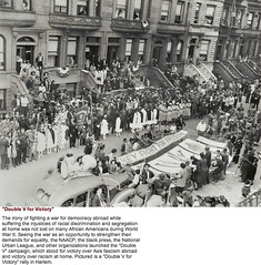
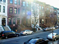
A scene linking a panorama taken from the meridian of Malcolm X Blvd, between 119th and 120th Street, and a panorama (SW) on 119th, between Malcolm X and Adam Clayton Powell. A modern day version of the historic 1942 picture above is visible in the previous post.
6th grader Chris' house is visible in one of the panoramas. Here he tells of memories he has of the scene. According to my pal Steve Schwartz, Bette Milder owns a small white modern structure housing a gallery that is next to Chris' building.
119th Street History (A Prelude To The 119th Street Panoramc Scene)
One of the many things I learned in reading Striver's Row was the pressure to end some of the humiliations of segregation while Black America's was enlisted to defeat fascism abroad. I was aware of the struggles of the Tuskegee Airmen, but that was tame compared to some of the actual incidents of race wars in southern bootcamps. Above is a picture taken in 1942 on 119th Street. I found at the inmotionaame site Here is a link to a larger image of that site with more background information
I did some neighborhood exploring to find what that Double V site on119th Street looks like today. I wonder whether any of those people in the 64 year old photo are still there. I'm nuts enough to start knocking on doors to find out. Here's a link to an enlarged version of that image with some out-takes.
I did some neighborhood exploring to find what that Double V site on119th Street looks like today. I wonder whether any of those people in the 64 year old photo are still there. I'm nuts enough to start knocking on doors to find out. Here's a link to an enlarged version of that image with some out-takes.
Panoramic Scene Of The "Dunk" In West Providence, R.I.
The Harlem Globetrotters played at the Dunk on 3/24/07 . Located near the Federal Hill section in West Providence. This panoramic scene connects a court-side view of the arena with one outside towards the NW
About the Dunk
The Dunkin’ Donuts Center, aka "The Dunk," Providence is a 14,500 seat indoor sports, entertainment and tradeshow venue. Home of the AHL Providence Bruins and the Providence College men’s basketball team, the arena hosts touring family shows, concerts, and other special events throughout the year. The arena recently launched a $62 million renovation and upgrade to the facility that will include all new seats, a sound system and video scoreboard, facility and concession upgrades, luxury suites, a redesigned concourse and lobby, and a bridge connector to the Convention Center. The arena will remain operational during renovations, with a grand unveiling scheduled for the 2008-2009 season.
Dunkin' Donuts Center Providence, One LaSalle Square, Providence, RI , 02903
Tiverton, Rhode Island Panoramic Scene
A panoramic scene made from two panoramic movies: one movie in front of Gray's Ice Cream in Tiverton, Rhode Island (16 East Road) and another just south in the Gray Ice Cream parking lot. (Summer 2007). Tiverton is just north of Little Compton
Little Compton, Rhode Island Panoramic Scene
A panoramic scene made from two adjacent panoramic movies at the beach in Little Compton, Rhode Island. The first movie is just east of the second (Summer 2007)
City Hall Panoramic Scene
A panoramic scene made from three panoramic movies taken in the vicinity of City Hall Park in June of 2008
CCNY Panoramic Scene
A panoramic scene connecting (look for the hot spots) the middle of the CCNY campus to (West) Amsterdam Avenue, between 137th and 138th Street. The public school park was once the site of the Hebrew Home for the Boys. It was that home that played an integral part in Gail Carson Levine's wonderful kids' historical fiction book called "Dave At Night."
Tuesday, June 10, 2008
Panoramic Scene: 590 Madison Avenue
A panoramic scene made from two panoramic movies: one movie inside the 590 Madison Avenue Atrium (the site of a 6/10/08 jazz performance by the Houston Person Quartet) and a movie directly north on 57th Street and Madison Avenue
Panoramic Scene Of Canarsie Pier
A panoramic scene made from three panoramic movies: two adjacent movies from the Canarsie Pier and one slightly northwest to a park on Seaview Avenue (at approximately Remsen Ave.). This was done on the night of 6/9/08
Monday, June 9, 2008
DiFara's Pizza Panoramic Movie
A panoramic movie of the intersection of Avenue J and E. 15t Street. The location of the famous DiFara's Pizza
Red Hook Pier Panoramic Scene
A panoramic scene made from three panoramic movies: two movies from nearby Red Hook Piers and one movie in Louis J. Valentine Park which is adjacent to one (more northern) of the piers. This was done on the night of 6/6/08 during the Red Hook Waterfront Arts Festival
Panoramic Movie From Brooklyn Pier
A panoramic movie made from the pier adjacent to the south side of the Brooklyn Bridge (on the Brooklyn side). Not my best effort as there was much movement going on. A large party from the Brooklyn District Attorney's Office was taking place at the Bargemusic and folks were exploring the telectroscope. Knickerbocker Village can be seen across the river to the right of the Bridge
Sunday, June 8, 2008
Seneca Village Panoramic Scene
A panoramic scene that connects three panoramas that include the sites where Seneca Village was (now included in Central Park). The first centers around West 85th Street and Park Drive. The second, looking southeast over a rise into another section which is bordered by trees and small hills. The third is to the right of the second, also SE, but more S. Look for the "hot spots" that link the three panoramas
Resources for learning about Seneca Village
.. The pictures are a combination of the current Seneca Site located between 82nd and 89th Streets and Seventh and Eighth Avenues (closest cross street now being Central Park West) and images from an historical fiction story about the village called, "The Lost Village Of Central Park." The current images show scientists and their students doing a Geoarchaeological study
Talking at the Slavery In New York exhibit that was at the NY Historical Society.
Part of a tour I found on youtube of Seneca Village in Central Park. It was done by folks from the Central Park Conservancy
Panoramic Movie: Corporate Drive, East Garden City, Long Island
A panoramic movie made in the parking lot of a Target in East Garden City, Long Island that borders Corporate Drive
Panoramic Scene: Old Country Road, East Garden City, Long Island
A Panoramic Scene connecting a panoramic movie made in the parking lot to a panoramic movie made from the south side of Old Country Road
PS 154 Panoramic Scene
A panoramic scene linking a panoramic movie taken in the schoolyard of PS154 to a panoramic movie of the intersection of Sherman Street and 11th Avenue. Look for the "hot spots" that link the two panoramas.
Questions for panoramic movie
1. How many people are sitting at the tables? Can you describe two of them
2. Can you describe what's going o in the area of the schoolyard where there is a picture of a shark on a yellow background?
3. Using the hot spot to link to the movie on the block intersection, can you describe where a motorcycle is located.
Questions for google map
1. Name 3 blocks that border the school.
2. If you go southwest you will see a thick yellow line. What does that represent.
3. In what direction would you go to get from the school to Prospect Park?
Saturday, June 7, 2008
Marcus Garvey Park Panoramic Scene
A panoramic scene linking a panorama taken from high up in the park to one at street level (to the West). Look for the "hot spots" that link the two panoramas.
Questions for panoramic movie(s)
1. Describe the car that is parked under the 121st Street sign (use the hot spot to go the second movie)
2. What time of the year was this movie made? How can you tell?
Questions for google map
1. What are the 4 blocks that surround Marcus Garvey Park?
2. What avenue will you reach if you go two blocks west (go left) of Marcus Garvey Park?
Panoramic Movie Of Marcus Garvey Park
A panoramic movie taken at street level at Marcus Garvey Park (formerly Mount Morris Park-119th Street-124th Street, 5th Avenue)
Marcus Garvey Park is one of the oldest public squares in Manhattan. Central to the life of Harlem for more than 150 years, it has served as a meeting place for neighbors, a front yard and play area for schoolchildren, and a holy place for members of local churches. Known as Mount Morris Park for more than a hundred years, it was originally part of the estate of Metje Cornelius Kortright. The name Morris became attached to the site by the 1830s; possible sources include Robert H. Morris, elected mayor in 1841, and a family affiliated with a racetrack that once operated nearby.
Panoramic Movie: Broad And Wall Street
A panoramic movie made on the intersection of Broad an Wall Street
Questions for panoramic movie
1. What street is marked with the red arrow? Can you explain your the reason for your answer?
2. Can you describe the place where there are two armed policeman
Questions for google map
1. Why is Broadway marked with a yellow line?
2. Describe how you would walk southeast on Wall Street from point A to the East River. Ex. I would walk southeast on Wall Street and cross William Street then I would continue southeast and cross....
Friday, June 6, 2008
Coleman Oval Panoramic Movie
A panoramic movie taken in Coleman Oval Park near Knickerbocker Village
Questions for panoramic movie
1. Name two kinds of activities that are going on in this movie
2. Can you make a guess at what time of day this might be and tell why.
Questions for google map
1. What bridge is near this scene?
2. About how far away is the river?
Thursday, June 5, 2008
Red Hook Park Panorama
A panoramic movie taken in Red Hook Park In Brooklyn on 5/6/08
Questions for panoramic movie
1.What do you think is the tall structure in the rear of the panorama?
2. About how many people are visible in the panorama. (you may have to zoom in and out)
Questions for google map
1. What four blocks border Red Hook Park?
2. Can you name another park in the area?
Hall Of Fame Panorama 2
A panoramic movie taken in the World Series' history section at the Hall Of Fame
Old Stone House Panoramic Scene
A panoramic scene connecting a panoramic movie taken in the Old Stone House, with a panoramic movie taken in the connecting JJ Byrne Park,
Questions for panorama:
1. This panorama was taken on Monday, June 2nd. What time of the day do you think it is and tell why.
2. What do you think the big map shows in the Old Stone House (in order to find the map you have to find the hot spot to go from the park panorama to the panorama in the stone house)
Questions for google map:
1. On what block is the Old Stone House located?
2. What large park is close to the Old Stone House?
About the Old Stone House
The Old Stone House is a modern reconstruction of the Vechte-Cortelyou House, a 1699 Dutch stone farmhouse with important ties to American history.
Today, the Old Stone House is operated as a historic interpretive center dedicated to its crucial role in the American Revolution and in the evolving histories of Brooklyn, New York and the United States.
The Old Stone House serves as a dynamic community resource through its education programs and events. In addition to historical exhibits open to the public, the House is available by appointment for tours, classes and rentals.
Below is a portion of My Battle Of Brooklyn Map
I "google mapped" the excellent geocache done by Alan2 at geocaching.com. This is Phase 5 of the Battle. It has 5 stops. I've supplemented the geocache with slide show movies I made and other resources on the Battle of Brooklyn as well as other events in Brooklyn history.
The markers are set at approximate locations. Also note slide shows are downloadable (just wait until it fully loads and use "control click" on a mac). The automatic timed slide shows can also be paused at any time by clicking on the movie. A double click will then resume it.
As of late I have added many other Brooklyn history resources, including information on the historic Dutch homesteads (these have the yellow house icon). Much of that information comes from www.bklyn-genealogy-info.com
Tuesday, June 3, 2008
Grand , Essex, Delancey, Broome Street Panoramic Scene
The panoramic scene connects three panoramic movies : a panoramic movie taken at the intersection of Grand and Essex, a panoramic movie taken of Essex looking North to Delancey, and a panoramic movie of the film site in a parking lot at Broome and Norfolk. Look for the hot spots that link one movie to another.
Corlear's JHS 12 School Yard-Grand And East Broadway Panoramic Scene
From 12/15/07
A panoramic scene linking a panorama of a movie in the school yard of the old Corlear's JHS 12 (at intersection of Jackson St, Grand Street and Henry Streets) to a panoramic movie of the intersection of Grand and East Broadway.
Monday, June 2, 2008
Alfred E. Smith Projects Panoramic Scene
A panoramic scene connecting two panoramic movies of the Alfred E. Smith Projects, featuring the lovely gardens
Sunday, June 1, 2008
Catherine Street Panoramic Scene
A panoramic scene connecting a panoramic movie of Catherine and Cherry Street to a panoramic movie of Catherine and South Street. Look for the connecting hot spots
QuickTime VR: Tanahey Park
Updated 6/1/08 with full featured vr tools that show zoom and pan and hot spots
from 11/23/07: A Quicktime VR Movie of Tanahey Park (western section)
After Thanksgiving my family took a trip to Boston. My daughter was visiting a camp friend who lives in Quincy. I was inspired by the geeky surroundings of the Hotel@MIT in Cambridge (run by Hilton and about 25% less than a Boston Hotel) That last proviso was for my father in case he was "listening" and I figured out the code to embed a vr movie. Actually I just copied it from another site and made adjustments. Probably any 16 year old kid here could do it blindfolded. Anyway it allows me to post many of the vr movies I've made that I had put on this site. The only problem is that the hot spots don't appear. The hot spots allow you to link to other vr movies. Good enough for now.
Tanahey didn't look like this 50 years ago and there was no hockey rink. Instead there were shuffleboard courts. I don't know why but I remember ringelevio home bases originating here. I was a lousy ringelevio player since I was pretty slow. I do recall, however, that I was a decent base runner by judging well where a ball was hit. I would also introduce the element of surprise by sliding on games played on concrete. I still have some scars.
As for fleet afoot Marty B and Marvin Kuperstein were among our fastest runners. Marvin was not only the fastest of us Jews, but he could beat any of the Italians and Irish and even the few black kids in the neighborhood.
Tanahey playground was named for local civic and political leader Martin F. Tanahey (1874-1930). Born and raised in this Lower East Side neighborhood, Tanahey held various public offices over 22 years. He served as chief clerk in the Labor Department of the State of New York and later became assistant appraiser of the Port of New York, the busiest port in the world for the first half of the 20th century. He also was an assistant government appraiser in President Woodrow Wilson's administration. In 1922, Tanahey was elected to the Board of Alderman from District 1, which includes the Lower East Side, and remained an alderman the rest of his life. Tanahey was a chief lieutenant of Democratic Party leader Thomas F. Foley (1852-1925), a saloonkeeper and politician associated with Tammany Hall for whom nearby Foley Square is named. Martin F. Tanahey died of pneumonia at his home at 177 Cherry Street in 1930.
Tanahey Park (East) Panoramic Movie
A panoramic movie taken in the eastern section of Tanahey Park (closer to Market Street in February of 2007
Hall Of Fame Panorama 1
from 1/13/08: A panoramic movie taken in the Babe Ruth section at the Hall Of Fame
Chinatown Panoramas With Students
Originally posted 12/10/07
I did these about 5 years ago with 5-6 Chinese bilingual students in Ms. Yang's class at PS 20. They were mostly recent immigrants who spoke little or no English. I had found the vr movies online on a panorama site and converted them to a quicktime version. I then had the kids narrate what they viewed.
Later they wrote out their narrations so there would be a listening and speaking and writing connection. Did I really know what I was doing? No, but it seemed logical and the kids enjoyed it and were very proud when they got to show these projects at a learning fair.
The first panorama was taken on Pell Street. The second was taken at the intersection of Canal and Mott. The third at the Kimlau Square at Chatham Green
The fourth, above, is taken on Doyers Street. The Vietnamese restaurant with the yellow sign used to be an old hangout of mine in my 20's. It was then called Wah Kee
The fifth is taken at the intersection of Pell and Mott and you can see Transfiguration Church. I could swear the woman in the purple and black ski jacket at the end of the clip is Lori Grasseli, who I used to work with. The sixth below is on Pell Street and shows much of the same scene as the first movie
Panoramic Scene 1: 117th And Malcolm X Blvd To Mr. Wright's Class
A panoramic scene connecting Malcolm X Boulevard and 117th Street to a 6th grade classroom on the 3rd floor of PS 149 which is NE in the pan. A hot spot is provided to return in a SW direction to the Boulevard. The hot spot is approximately where the room is located. The hot spot back to 117th Street is also in approximately the correct spot.
Ashleigh's tall apartment building is visible in the distance in this scene. She talks about her grandmother.
Subscribe to:
Comments (Atom)


